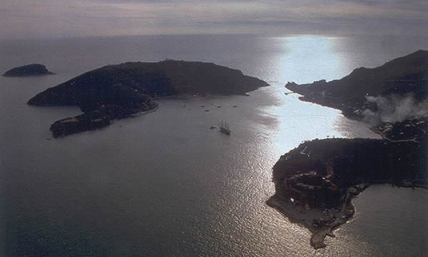
| Just off the coast of Porto Venere are the three islands that make up the archipelago of Porto Venere: Palmaria, Tino and Tinetto, representing the heart of the Regional Nature Park of Porto Venere, founded on 20th September 2001.
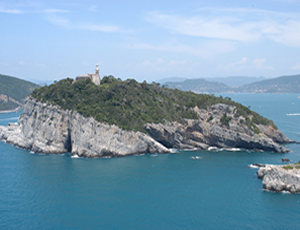
The isle of Tino, where interesting ruins from the 11th Century can be seen including an old little abbey dedicated to Saint Venerio, is closed military territory, hence access is limited to one or two days a year when religious celebrations are held on the anniversary of the Saint's death (13th September).
The abbey was constructed in the 11th Century on top of the remnants of a 7th Centruy chapel on the site where the body of the saint, who was born on Palmaria, but died a hermit on Tino, was found.
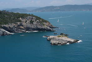
Tinetto is a rock 18 metres high, and practically without vegetation. It has some ancient ruins, which testify to the presence of religious communities in this area. There are two distinct buildings: on the western side of the island was a small 6th Century oratory with an apse pointing eastwards from where a more complex building arose. The latter, which consisted of a church with two naves and cells for monks, shows different phases of construction up to the end of the 11th Century when it was destroyed by Saracen raids.
|
Another interesting bit of information is the existence on the islet of an endemic reptile, the "pordacis muralis tinettoi", a very rare species of lizard.
Of the three islands, Palmaria is the most well-known and frequented, above all by locals from nearby La Spezia who visit the island during the summer season.
Thousands of tourists pour onto its beaches to swim in the crystal clear waters surrounding its shores.
Palmaria (the name probably derives from the word "Balma" - grotto, rather than from the presence of dwarf palm trees) has an interesting landscape due to the unusual features of the terrain: on the eastern side where the land slopes gently down to the sea, it is covered by rich Mediterranean vegetation; on the western side there are steep cliffs some 188 metres high.
To highlight its characteristics we have taken a description of one of the most interesting routes which is taken during the most important sporting event "the Ecological Walk of Palmaria", which takes place every year in May.
The departure is from the Terrizzo, the ferry quay from where the path goes east towards the Fort Umberto I - today called "the Sea Fortress" - built in the last century by Count Cavour during the reign of the Savoys, and later turned into a prison and used as such until the fifties.
On the point known as "Punta Scola" the path moves upwards and looks over Schenello Bay. After the recent restoration works the fortress has become the venue of theme exhibitions, congresses, plays and important cultural events, and is managed by an association called "Marenostrum". Just before the fortress the road splits and following the right fork, takes you to the almost uninhabited eastern side of the island where the path winds through perfumed broom bushes, wild orchids, delicately scented myrtle and other plants of the mediterranean bush.
The path leads up to Mariella Point and then continues above the "Grotta del Roccio" and the Bay of Pozzale where the Portoro marble quarry is situated. This quarry, where the precious black marble with a golden vein is to be found, was operational until a few years ago.
|
From here the steep climb begins towards the "Capo dell'Isola" where there are several small caves, amongst which the remarkable "Grotta dei Colombi" where human and animal remains have been found from the Neolithic period and which are now on display in the Civic Museum in La Spezia. The path continues upwards to the top of the island where the Lighthouse and the Fort Cavour dominate all.
The downward path winds through Aleppo and cluster pines until it comes to the most north-western point of the island near a shrine that used to hold the bust of King Carlo Alberto, erected in his honour after he visited the stone quarry in 1837. On the opposite side of the straight, the little church of St Peter, with its unique outline, stands out against the sky with in the background the impressive limestone cliffs of the Muzzerone.
Accompanied by the unique view of the fortress-houses which make up the seafront of Porto Venere, the path takes one back to the Terrizzo from where the trip started. As the whole of Palmaria falls within the "Regional Nature Park of Porto Venere", the town council has made important moves aimed at putting its natural and scenic beauty to fruitful and intelligent use. For this reason the CEA (Centre for Environmental Education) was set up in 1994, managed by the town council through the company "Tourist and Port Services of Porto Venere"). The centre is located in a fort that was once a military experimental battery. It offers self-catering accommodation with big dormitories and it has both closed and open spaces for studying and creative activities. Each year a lot of young people make it their destination, motivated by their interest in environmental issues and to expand their knowledge. From this point of view, the CEA is of great importance to the success of the park, especially as far as youngsters are concerned. Today it is gradually becoming a centre for tourists who are aware of and are educated with the values of the environment, experimentation, study and research.
|